sales@sorbus-intl.co.uk
Tel: 01373 475540 |
 | |
 | ||
| Products > 3D Laser Mapping |
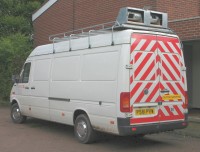 |
3D Laser Mapping Technology StreetMapper Using the very latest laser scanning technology coupled with high precision navigation system, StreetMapper offers, a novel 3D mapping system to scan roads, buildings, vegetation and overhead wires from a moving vehicle. |
|
|
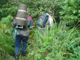
Stop & Go A Stop & Go laser scanning service can also be provided for areas that either require higher definition than the mobile system or have limited access. This method gathers high definition laser scanning data and digital images while the equipment is stationary, and then moves on to repeat data capture at successive points. Although this method is not as quick as Rapid 3D Mapping, Stop & Go delivers the highest quality results. |
|
| |
![]()